

ADVANCED DRONE SOLUTIONS
FOR PRECISION ANALYSIS

ADVANCED ENVIRONMENTAL, AGRICULTURAL, AND CONSTRUCTION ANALYTICS
OUR VISION
At Carta Drone Services, we are revolutionizing the way environmental, agricultural, and construction site analysis is conducted using advanced drone technology.
Our team of experts is dedicated to providing precise, actionable insights that enhance decision-making and optimize outcomes. We are committed to pushing the boundaries of aerial data collection to deliver exceptional value to our clients.
Carta Drone Services is a subsidiary of Osprey Environmental Associates, Inc.
OUR SERVICES
Advanced Data Collection for Enhanced Insights

AERIAL Natural Resource Mapping and Classification
At Carta Drone Services, our advanced drone technology revolutionizes natural resource mapping and classification. By capturing spatially corrected high-resolution aerial imagery, we produce detailed and accurate maps that depict natural resource distributions across various landscapes.


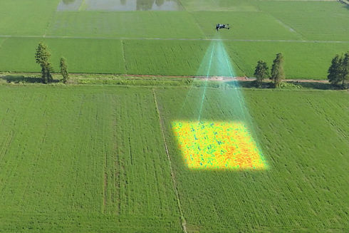
Agricultural Analysis
At Carta Drone Services, we leverage advanced drones equipped with multispectral sensors to provide comprehensive agricultural analysis. This technology offers numerous benefits, including enhanced crop health monitoring, optimized resource management, improved yield predictions, and efficient field scouting.
Construction Site Analysis and Inspection
We offer comprehensive construction site monitoring and inspection services, providing real-time progress tracking, safety inspections, and quality control. Our drones capture high-resolution imagery and detailed 3D models of construction sites, enabling precise measurements and timely assessments. By delivering up-to-date information on site conditions, Carta Drone Services helps you streamline project management, ensure compliance, and maintain high standards of safety and quality throughout the construction process.


WHY CHOOSE US
Unmatched Expertise and Innovation
At Carta Drone Services, our team of professional drone pilots, GIS analysts, and biologists brings together a unique blend of expertise and sophisticated technology to support your projects. We pride ourselves on delivering precise and actionable insights through advanced drone technology, RTK systems, and multispectral sensors. Our comprehensive approach ensures you receive detailed, accurate data for environmental analysis, agricultural management, and construction site monitoring. By partnering with us, you not only benefit from our specialized knowledge and cutting-edge tools but also save time and money through optimized resource management and efficient project execution. Choose Carta Drone Services for unparalleled expertise, precision, and cost-effective solutions.
INDUSTRY COLLABORATION
Our
Equipment
At Carta Drone Services, we handpick our equipment from reputable companies known for their high-quality products and cutting-edge technology. By selecting the most advanced drones, sensors, and GNSS systems we ensure that our clients receive the highest quality data and work products. Our commitment to using top-tier equipment allows us to deliver precise, reliable, and detailed insights for all your environmental, agricultural, and construction needs. Trust Carta Drone Services to provide exceptional data quality with industry-leading technology.
.jpg)
.jpg)
.png)


.png)

.jpg)
.png)
.jpg)
